


Geography
Our Geography Subject Champion: Mrs. Gaskell
INTENT FOR GEOGRAPHY AT LITTLE HOOLE PRIMARY SCHOOL
At Little Hoole, we want our children to have a curiosity and fascination of the world and its people that will remain with them throughout their lives.
Through our Geography curriculum, we want to prepare them with the knowledge, skills and understanding to make sense of their world and to face the challenges that will shape our societies and environments at local, national and global scales.
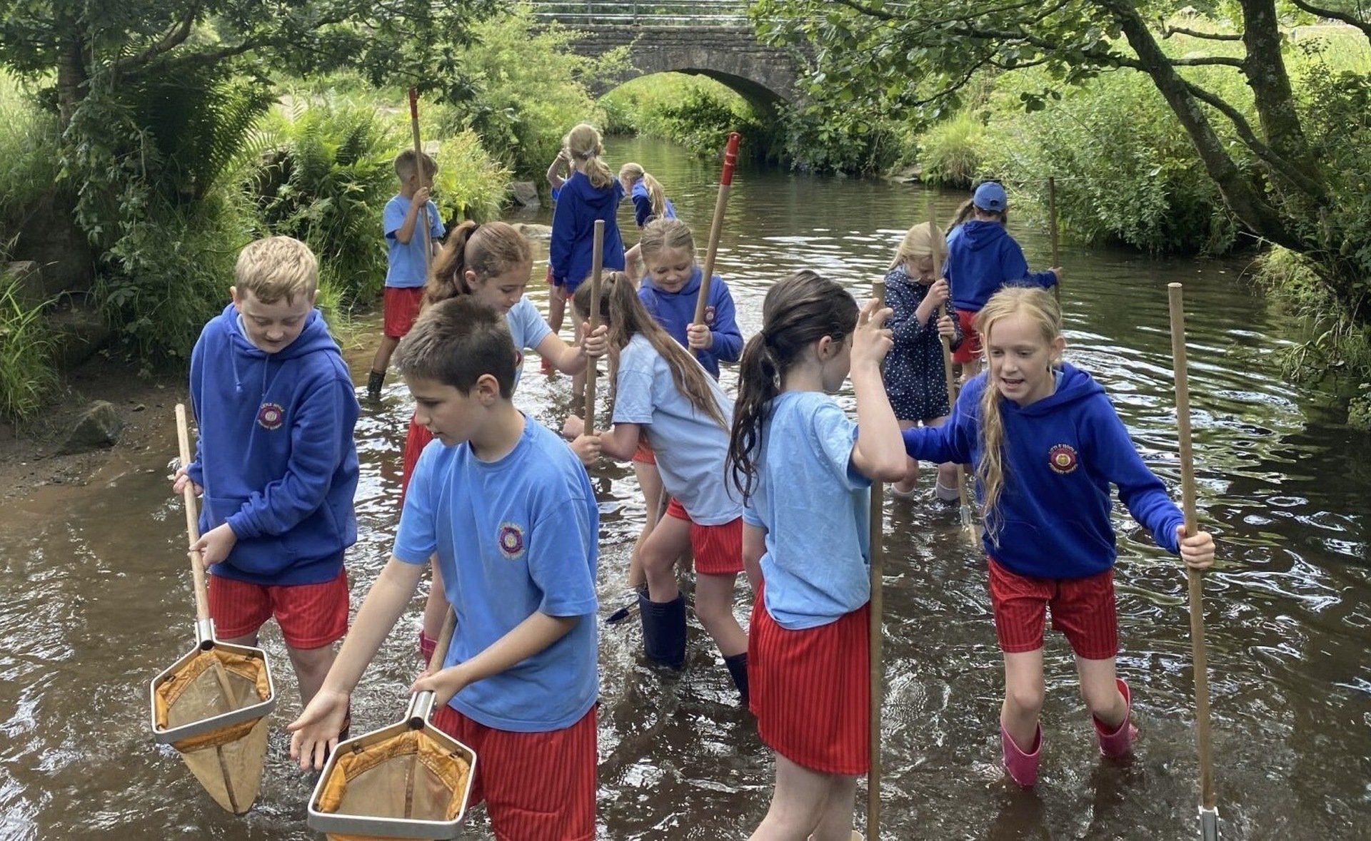
We aim to deliver the curriculum using a rich and multi-faceted approach. A wide range of visual resources and practical activities are used in order to spark awe and wonder for the subject. Geographical breadth of study is delivered through classroom-based teaching, as well as field trips guest speakers, local walks, and home-learning projects.
We want our children to be inquisitive, questioning learners. We will provide opportunities for them to undertake enquiry based learning, and develop skills using local fieldwork trips to enhance their experiences.
At Little Hoole we also aim to ensure that the children are aware of current affairs in relation to their local area, and on a national and global scale. We intend to develop a keen sense of awareness and pride in where they live and to encourage the children to engage in changes and aspects of life in Lancashire.
We aim to inspire pupils to become global citizens by exploring their own place in the world, their responsibilities to the environment and the sustainability of the planet.
Additionally, it is our intent that there is visible progression throughout the school years by building upon prior knowledge and skills while learning new ones and developing these further. Children revisit topics and threshold concepts within phases to deepen and embed their learning.
Our Geography Subject Overview
| Aut | Spr | Sum | ||||
| Reception |
In Reception the curriculum is based on an active learning approach that allows children to explore and develop their skills through continuous provision. Early Learning Goals:
Across the course of the year, the topics they will cover are:
|
|||||
| Year 1 |
What is it like here? Locating where they live on an aerial photograph and identifying local features. Creating maps using classroom objects and drawing simple maps of the school grounds. Use maps to follow simple routes around the school grounds and carrying out an enquiry about how to improve their playground. |
What is the weather like in the UK? Studying the countries and cities that make up the UK and learning about the seasons and their associated weather. Considering how we change our behaviour in response to different weather and keeping a weather diary or record. Investigating the UK’s hot and cold places using weather maps with a simple key. |
What is it like to live in Shanghai? Identifying continents, oceans and countries outside the UK using a world map (with a focus on China). Identifying physical features of Shanghai using aerial photographs and maps and as well as human features, through exploring land-use then comparing these features to those in the local area. Making a simple map using data they have collected through fieldwork. |
|||
| Year 2 |
Would you prefer to live in a hot or cold place? An Introduction to the basic concept of climate zones and mapping out hot and cold places globally. Comparing features in the North and South Poles and Kenya as well as in the local area. Learning the four compass points and the names and location of the seven continents. |
Why is our world wonderful? Identifying features and major characteristics of the UK and learning about some of the amazing places in the world. Naming the oceans and locating these on a world map. Exploring what is unique about the natural habitats in their locality and using fieldwork to investigate and present this. |
What is it like to live by the coast? Naming and locating continents and oceans of the world in an atlas and revising the countries, cities and surrounding seas of the UK. Learning about the physical features of the Jurassic Coast and how humans have interacted with this over time, including land use, settlements and tourism. |
|||
| Year 3 |
Why do people live near volcanoes? Learning how the Earth is constructed and about tectonic plates and their boundaries. Looking at how mountains are formed, explaining the formation and types of volcanoes and the cause of earthquakes. Mapping the global distribution of mountains, volcanoes and earthquakes and giving consideration to the negative and positive effects of living in a volcanic environment and the ways in which humans have responded to earthquakes. |
Who lives in Antarctica? Learning about latitude and longitude and how this links to climate. Contemplating the tilt of the Earth and how this impacts the Antarctic circle and global temperatures. Exploring the physical features of a polar region and how humans have adapted to working there, taking into account that there is no permanent population. Studying Shackleton’s expedition and planning their own expeditions, using mapping skills. |
Are all settlements the same? Exploring different types of settlements and land use, and the difference between urban and rural. Describing the different human and physical features in the local area and how these have changed over time. Making land use comparisons between the local area and New Delhi to find key similarities and differences between these two locations. |
|||
| Year 4 |
Why are rainforests important to us? Focussing on the link between biomes and climate, locating the Amazon rainforest and explaining how the vegetation in a tropical rainforest is defined by the two Tropics. Investigating the physical features and layers of the Amazon rainforest, considering how plants adapt to these conditions. Learning about the people who live in the rainforest, discussing the impact of human activity locally and globally. |
Where does our food come from? Looking at the distribution of the world’s biomes and mapping food imports from around the world, learning about trading fairly with a specific focus on Côte d'Ivoire and cocoa beans. Exploring where the food for school dinners comes from and the pros and cons of local versus global. |
What are rivers and how are they used? Exploring the different ways water is stored and moves, developing an understanding of the water cycle. Naming and mapping major rivers both in the UK and globally. Learning about the features and courses of a river and how they are used by humans, and studying a local river to identify these features. |
|||
| Year 5 |
What is life like in the Alps? Discovering the climate of mountain ranges and considering why people choose to visit the Alps, focussing on Innsbruck and identifying the human and physical features that attract tourists. Then applying this learning to investigate tourism in the local area, mapping recreational land use and presenting their findings. |
Why do oceans matter? Exploring the significance of our oceans, learning how humans use and impact them and how this has changed over time. Studying the Great Barrier Reef and how plastic and pollution is damaging this marine environment, and considering positive environmental changes that can be made including making eco-friendly choices. Using fieldwork skills to investigate the amount and type of litter in a marine environment. |
Would you like to live in the desert? Recapping biomes with focus on hot desert biomes and their various characteristics, mapping the largest global deserts. The Mojave Desert is used as a case study to support learning about the physical features of a desert. Exploring how humans use deserts and the environmental threats that can occur in this landscape.
|
|||
| Year 6 |
Why does population change? Looking at global population distribution, thinking about why certain areas are more populated than others. Exploring the factors that influence birth and death rates and using case studies to illustrate these. Exploring the social, economic and environmental push and pull factors that influence migration. Fieldwork is carried out to explore the impact of population on the local environment. |
Where does our energy come from? Learning about time zones around the world while exploring natural resources and energy found in the United States and the United Kingdom. Learning about renewable and non-renewable energy sources and the impacts these have on society, economy and environment. Carrying out a fieldwork investigation, looking into the best location for a solar panel on the school grounds. |
Can I carry out an independent fieldwork enquiry? Planning and carrying out an independent enquiry, exploring an issue in the local area. Developing an enquiry question, designing data collection methods, and recording, analysing and presenting the findings. | |||
Galleries
Yr 1


